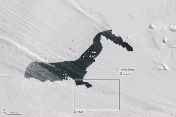
Pine Island Glacier, along with neighboring Thwaites Glacier, garners attention as one of the main pathways for ice flowing from the West Antarctic Ice Sheet to the Amundsen Sea. It has also been one of the fastest-retreating glaciers in Antarctica, and ice on its seaward edge regularly fractures and calves off icebergs—some large enough to be named. In October 2024, however, it was the atmosphere above the ice that stole the show with a display of blowing snow and “sea smoke.”
Satellites are usually unable to capture clear images of these near-surface atmospheric phenomena because clouds tend to be present when they occur, said Christopher Shuman, a University of Maryland, Baltimore County, glaciologist based at NASA’s Goddard Space Flight Center. This was not the case on October 10, 2024, when the OLI (Operational Land Imager) on Landsat 8 acquired this image. It illustrates “the power of the wind,” in this case racing out to the edges of the continent from the cold interior, he said.
In this image, “sea smoke” appears to form at the very edge of the glacier’s terminus, as well as over open water along its northern edge, Shuman said. This phenomenon occurs because of a stark difference in temperature between the ice and the water surrounding it. Here, winds are pushing water and sea ice away from the ice front, driving an upwelling of relatively warm water to replace it from below. Sea smoke forms when cold air moves across the warmer water, and when the cold air cannot hold the water vapor it encounters, it quickly condenses into small ice crystals.
Read more at NASA Earth Observatory
Image: NASA Earth Observatory images by Wanmei Liang, using Landsat data from the U.S. Geological Survey.
Sci/Tech Climate Top Stories
