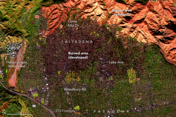
On the afternoon of January 11, 2025, NASA’s AVIRIS-3 (Airborne Visible/Infrared Imaging Spectrometer-3) flew aboard a B200 aircraft over Los Angeles County, where it captured images of several areas affected by wildland fires.
These false-color images show areas burned by the Eaton fire in Altadena and parts of Pasadena, Arcadia, and Sierra Madre. Charred trees and buildings in developed areas appear dark brown, whereas the burned wildland areas, particularly in Angeles National Forest, are shades of orange.
The Eaton fire ignited in the hills of Eaton Canyon, near Altadena, on the evening of January 7. By 10:30 a.m. the next day, the fire had quickly grown to cover more than 10,000 acres (40 square kilometers), according to Cal Fire. Around the time of this image on January 11, it had expanded to 14,117 acres (57 square kilometers), and the Los Angeles County Fire Department reported it was about 15 percent contained.
Photo Credit: NASA Earth Observatory images annotated by Lauren Dauphin using data from Airborne Visible / Infrared Imaging Spectrometer-3 (AVIRIS-3) instrument, via NASA Earthdata Search.
Health Sci/Tech Top Stories Climate

