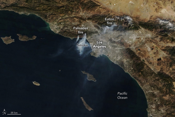
Destructive fires, fueled by a dry landscape and powerful Santa Ana winds, burned in the Los Angeles area in January 2025. Smoke from the Palisades and Eaton fires, which both broke out on January 7, was visible in satellite imagery for several days after they ignited. They were the largest of several fires that burned in the area as strong winds tore through the region.
The MODIS (Moderate Resolution Imaging Spectroradiometer) on NASA’s Terra satellite acquired this image (above) at approximately 10 a.m. local time on January 10. At this time, a red flag warning remained in effect in the area, which means conditions were favorable for the ignition and spread of fire.
Centered in the image, several distinct plumes streamed south over the ocean from the Palisades fire, which burned through the Pacific Palisades neighborhood and west into Malibu. The fire had spread to 20,400 acres (83 square kilometers) and was 8 percent contained by this point, according to Cal Fire. To the east, smoke billowed from the Eaton fire in and around Altadena. This fire had burned 13,700 acres (55 square kilometers) and was 3 percent contained at the time of the image.
Read more at NASA Earth Observatory
Image: NASA Earth Observatory images by Wanmei Liang, using MODIS data from NASA EOSDIS LANCE and GIBS/Worldview.
Sci/Tech Top Stories
