An international team of scientists using observations from NASA-German satellites found evidence that Earth’s total amount of freshwater dropped abruptly starting in May 2014 and has remained low ever since. Reporting in Surveys in Geophysics, the researchers suggested the shift could indicate Earth's continents have entered a persistently drier phase.
From 2015 through 2023, satellite measurements showed that the average amount of freshwater stored on land — that includes liquid surface water like lakes and rivers, plus water in aquifers underground — was 290 cubic miles (1,200 cubic km) lower than the average levels from 2002 through 2014, said Matthew Rodell, one of the study authors and a hydrologist at NASA’s Goddard Space Flight Center in Greenbelt, Maryland. “That’s two and a half times the volume of Lake Erie lost.”
During times of drought, along with the modern expansion of irrigated agriculture, farms and cities must rely more heavily on groundwater, which can lead to a cycle of declining underground water supplies: freshwater supplies become depleted, rain and snow fail to replenish them, and more groundwater is pumped. The reduction in available water puts a strain on farmers and communities, potentially leading to famine, conflicts, poverty, and an increased risk of disease when people turn to contaminated water sources, according to a UN report on water stress published in 2024.
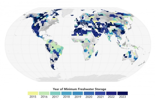
This map shows the years that terrestrial water storage hit a 22-year minimum (i.e., the land was driest) at each location, based on data from the GRACE and GRACE/FO satellites. A significantly large portion of the global land surface reached this minimum in the nine years since 2015, which happen to be the nine warmest years in the modern temperature record. (Photo Credit: NASA Earth Observatory/Wanmei Liang with data courtesy of Mary Michael O’Neill)
Health Top Stories Sci/Tech Climate

