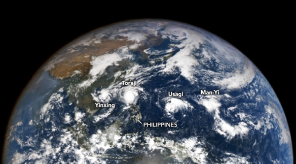
In an unusual sight, four storms churned simultaneously in the Western Pacific Ocean in November 2024. The Japan Meteorological Agency reported that it was the first time since records began in 1951 that so many storms co-existed in the Pacific basin in November.
At 8:55 a.m. Philippine Standard Time (12:55 a.m. Universal Time) on November 11, NASA’s EPIC (Earth Polychromatic Imaging Camera) imager on the DSCOVR (Deep Space Climate Observatory) satellite observed the storms—named Yinxing, Toraji, Usagi, and Man-Yi—visible in the image above. At the time of the image, the storms were either approaching the Philippines or had already passed over the islands and surrounding areas.
About 40 minutes before the image was acquired, Typhoon Toraji (locally known as Nika) made landfall on the northeastern side of the Philippines’ main island of Luzon. The storm unleashed flooding and brought power outages to Aurora Province. Landslides induced by the rain buried roads in the Cordillera mountain range. The Japan Metrological Agency reported that the storm reached peak intensity the night before, with sustained winds of 130 kilometers (80 miles) per hour.
Read more at NASA Earth Observatory
Image: NASA Earth Observatory image by Wanmei Liang, using data from DSCOVR EPIC.
Sci/Tech Climate Top Stories
